” نظام التوجيه المروري التفاعلي – Dynamic Traffic Guiding System “
This idea as an engineering innovation aims to address three problems that affect the safety and effectiveness of traffic on the roads:
Non Symmetrical Intersections
Unidentified Highways Enter/Exit and Parking Areas
Redirect Difficulties in Sensitive Traffic Areas
consists of three parts:
First: Traffic Problems in which we will systematically present the previous problems and monitor them in some cities of the Kingdom.
Second: Dynamic Traffic Guidance SystemIn this part, we will present the idea with its details and engineering drawings and explain how this idea can solve previous traffic problems.
The third section will conclude with a personal profile of the participant and their interest in the field of traffic safety as well as references and sources.
Part 1 > > Traffic Problems
1. Non-Aligned Traffic Intersection
1.1 Intersections Design
As defined by the American Association of State Highway and Transportation Officials (AASHTO); an intersection is the area where two or more roads cross. There are four main elements that must be present in the design of the intersection to achieve its objective effectively: human factors, traffic considerations, tangible components and economic factors. Under each of these elements, there are many concepts as follows:
-- Human Factors
Driving Habits
Drivers' Decision-Making Ability
Driver Prediction
Decision Time and Reaction
Compatibility with natural paths of movement
Pedestrian Uses and Habits
Bicycle Uses and Habits
-- Traffic Considerations
Design and Actual Capacity
Traffic as measured by time
Size and operational characteristics of the vehicle
Type of traffic (separation, confluence, intersection and compound movement)
Vehicle Speed
Overlapping Navigation
Collisions
Bicycle Movement
Pedestrian Movement
-- Perceptible Components
Intersecting Properties and their Uses
Intersection Vertical Alignment
Sight Distance
Intersection Angle
Actual Intersection Area
Speed-change lanes
Engineering Design
Lighting Equipment
Safety Features
Bicycle Signs/Lanes
Environmental Factors
Pedestrian
-- Economic Factors
Cost of Improvements
Power Consumption
The extent of the impact of controlling or limiting service corridors on overlapping residential or commercial properties where there are restrictions or prohibitions on traffic there
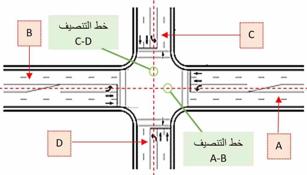
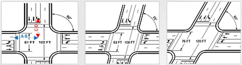
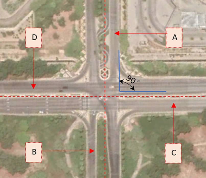
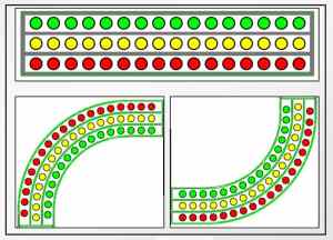
After knowing the four main elements that affect the effectiveness of the intersection design and the safety of traffic through it, we can now know the correct shape of the traffic intersection, which has two main characteristics that make it a regular intersection :
Opposite roads share the same center-line Fig1-1
Intersection alignment angle shall be 90° as far as possible but not less than 60° if not. (AASHTO Specified) Fig1-2
1.2 What is Non-Aligned Traffic Intersection?
Intersections where the above two characteristics do not apply and can be phrased as follows:
×Do not share opposite ways on a straight classification line Figure1-3
× Degree of intersection alignment less than 60 ° Fig . 1-4
1.3 Case Study – Intersections in the Eastern Province
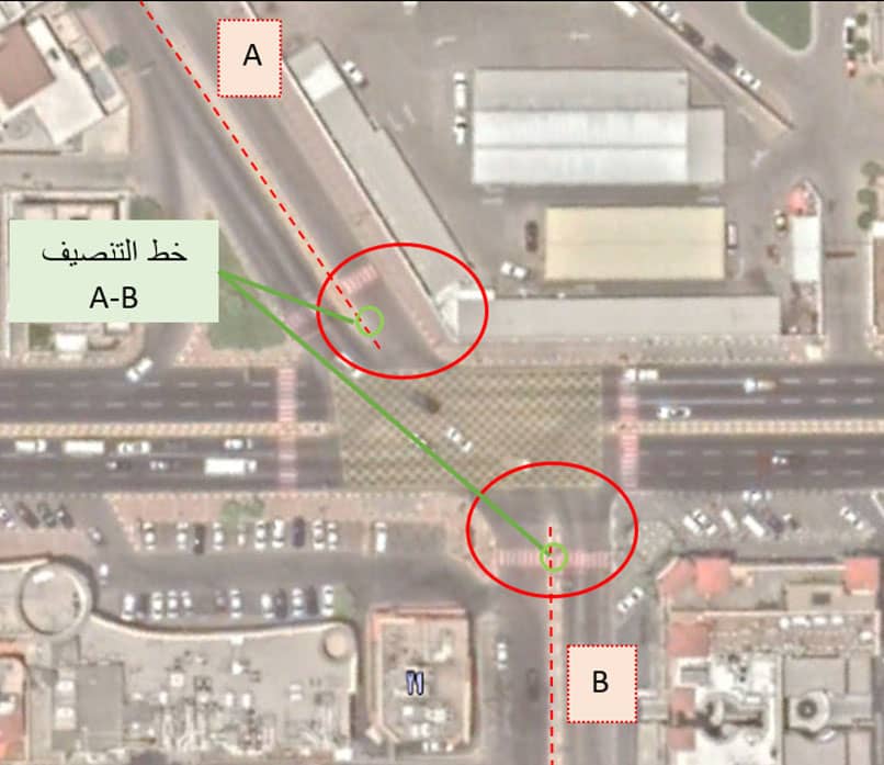
1.3.1 Al-Tabari Intersection-Prince Fahd bin Salman (Al-Khobar)
Figure1-5 shows the intersect of Streets A- Tabari with Street B- Fahd bin Salman, located in Al-Khobar city, where Street A corresponds to Street B, which requires that they have a common classification line and crosses them in a straight line, but it shows that they do not share the same bisecting line and do not cut them straight, which makes it an irregular intersect.
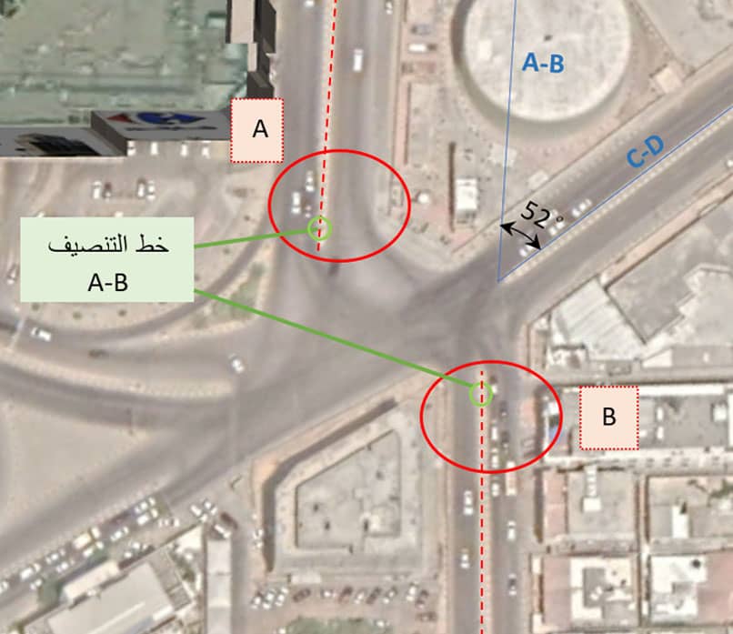
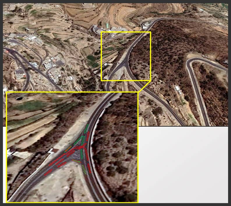
1.3.2 Yarmouk Intersection -Zaid Ibn Al-Khattab (Khobar)
In Figure 1-6, There are two overlapping issues in intersection: first one alignment angle is less than 60°, second: both opposite roads do not share the same center-line Since the angle between the opposite road (A-B) and the opposite road (C-D)= 52°. It is also obviously that A-Zayd Ibn Al-Khattab Street and B-Yarmouk Street are opposite, which requires their center-line to be common and straightly crossing, however it appears they do not share the same center-line , resulting in a non-crossing center-line through them, which classify the intersection as Non Symmetrical one
— 1.3.3 Intersection of Huwailat with Road 6
(Jubail Industrial City)
In Figure 1-7, this intersection shows the correct shape of traffic intersections where the opposite road (A-B) and (C-D) share bisection line, and the angle between them is equal to a right angle.
2. Unmarked highway ports and stops
2.1 What is Highway?
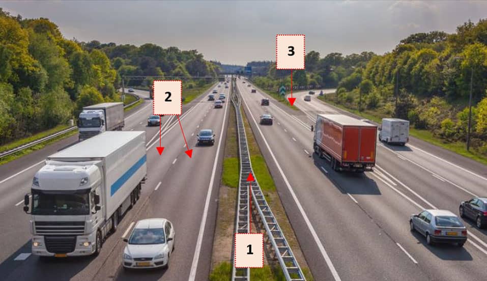
AASHTO has defined highway as the road which contains multiple lanes and one main barrier as separator between two ways traffic and allows high limit speeds.
The traffic in a highway is adjusted where direct entrance is not permitted except through a separated service road that controls traffic movement redirection.
Also highway sides must be closed so no pedestrian or animals can pass. Figure 1-8
Highway Ports and Stops
Highways contain side service areas such as gas stations and rest stops, as well as stop area along the way such as security checkpoints or toll gates.
These two elements require certain standard specifications for traffic safety and efficiency.
We will refer to these two elements, required specifications and overview the possible traffic issues that could be occurred to them.
— 2.2.1 Highway's Enter/Exit
Any access way leads out of highway called exit way such as gas station road or exit road.
On the other hand, entrance way is that leads to highway from sub roads or even other highways
— 2.2.2 Highway stops
Scheduled -non emergency- stops on highway such as security checkpoints and toll gates.
2.3 Traffic problems at highway ports and stops
The required specification which must be available in enter/exit and parking areas are guidance and clear redirect marks to highlight them over the usual traffic especially during night. Absence of these specification might cause lack of safety and efficiency over traffic. Here we will show a case study:
— 2.2.1 Case Study –Dhahran-Jubail Highway
Dhahran-Jubail Highway is 83.17 km long , we will study 3 areas along the highway where the traffic issues are there. Figure (1-10)
(A) Entry from Airport Road to Highway (B) Entry/Exit to Gas Station “Sahl” (C) Checkpoint Stop
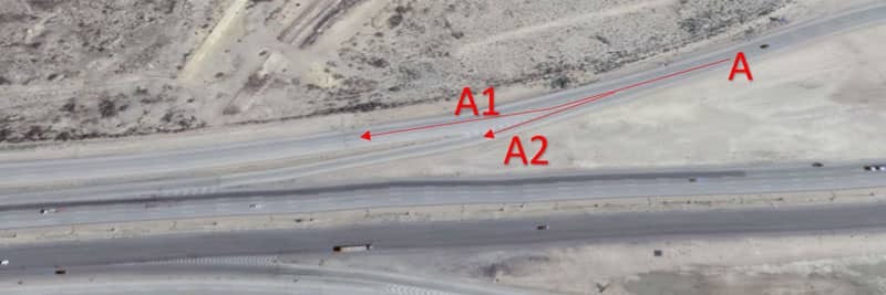
(A) Entry from Airport Road to Highway
Coming from the airport road, it is difficult to distinguish the multiple paths of the road ,especially in the evening. For example, the A1 lane to continue on the secondary service road and the A2 lane to enter the highway, both of these lanes appear as the usual road despite the presence of road marking.
The lack of clarity of these parameters affects the decision time to change the speed of the vehicle and is a traffic problem that affects safety and movement effectiveness. Figure 1-11
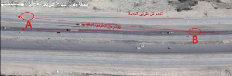
(B) Entry/Exit to Gas Station “Sahl”
The exit port to the gas station from highway point B could be more precise and distinctive, especially in the evening. The driver needs a more extended period and a slower speed to recognize the port's location and may recognize it late. However, the port is prevented by a regular heavy truck in the right part, which creates a cornering problem that may amount to a traffic accident. Also, if he enters the In-Road, there is a problem with the need for more clarity of the pickup point, point A, for vehicles already on the service road
(C) Checkpoint Stop
There is a security checkpoint In the middle of Dhahran-Jubail Highway with Figure 1-13 with many traffic issues :
There are no preamble marks once approaching checkpoint by less than 1000 m (Jubail Lane).
Left lane is being closed suddenly and inflexibly when approaching without preamble marks as well, all vehicles are forced to be distributed over the remaining three lanes.
The stopping point of the infringing vehicles is not clear and the cars exit from it to the highway. In conjunction with vehicles coming from the checkpoint unsafe.
There are no preamble marks once approaching checkpoint by less than 1000 m (Dhahran Lane).
The entrance and exit of the parking lots allocated to the checkpoint staff poses a serious risk to the safety of traffic, especially since the Dhahran route is rarely searched.
3. Routing Difficulties in Sensitive Traffic Areas
What are Sensitive Traffic Areas ?
Areas where traffic is restricted either due to certain security procedures or natural circumstances such as narrow terrain.
Traffic in these areas needs to be adjusted and managed in order to avoid traffic accidents or security violations.
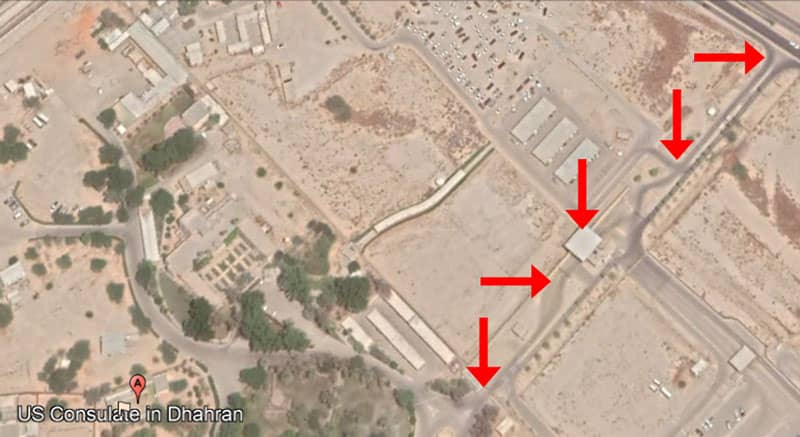
For example, in the Asir-Abha, in which there are diversity terrains and tourist roads , we can notice this issue in Bani Mazen-Al-Soudah Road in one of its bends where is many traffic overlapping occurring, indeed they are difficult to identify especially during night. Figure 1-14
Issue also appears at entrance of areas with security access, they are not distinguished from the normal areas. Also, after crossing the entrance, vehicles movement is not directed safely towards the destination. Figure 1-15
Part 2
Introduction
Dynamic Traffic Guiding System (DTGS) is integrated system consists of electrical and telecom engineering application aims to solve previous mentioned issues:
1- Non-Symmetrical Intersections
2. Unmarked Highway Entry/Exit and stops
3- Redirect Difficulties in Sensitive Traffic Area
The name was chosen because it describes the system as follows
System: it's one entire system that works integrally with its other components
Traffic Guiding: any traffic guiding according to specific scenario
Dynamic: system is interactively acting with its components and other vehicles as well
2. System Components
Dynamic Traffic Guidance System “DTGS” consists of the following main components with examples of them:
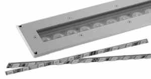
2.1 Linear LED Light
LED stands for Lighting Emitting Diode, it is An advanced lighting technology that saves energy and provide high efficiency, with many applications. Figure 2-1
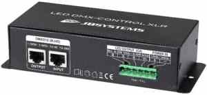
2.2 DMX Communication Protocol
In order to connect different system fixtures with control software , and among fixtures themselves we use DMX which stands for Dynamic Multiplex Protocol. Figure 2-2
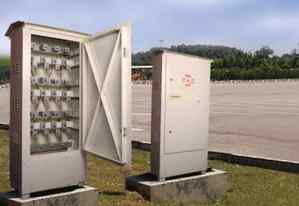
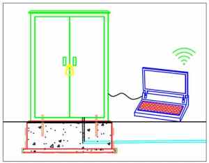
— 2.3 Control Cabin
The cabin through which we connect the system with the electrical power source and also through which we control the system and its components.Figure 2-3
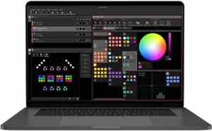
— 2.4 Software
A friendly user interface software to design the required scenario and make modifications before sending to system. Figure 2-4
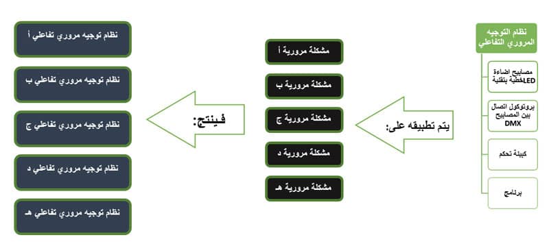
3. How does DTGS work?
The Dynamic Traffic Guiding System is a system that is designed specifically according to the traffic problem to be solved, but the components of the system remain the same, regardless different the problem, the following graphic shows the methodology of the system:
4. Dynamic Traffic Guiding System (DTGS) Engineering Design
4.1 System Overview. Figure 2-5
4.2 System Components
4.2 Linear LED Light
It is available in three standard shapes and supports the RGB tinting feature , which has a rubber material at the ends, a light-permeable reinforced layer and a stainless steel cast Aluminum, frame protected by IP-65 grade . Figure 2-7
4.2.2 DMX Communication Protocol
It has connection ports to connect the lamps to the main power supply and the control software. Figure 2.8.
4.2.3 Control Cabin
All electrical connections are integrated into special control panels and connected to the electrical power source, through which the connection is made with the program to set the required traffic scenario. Figure 2-9
4.2.4 Software
برنامج يتم تثبيته على جهاز الكمبيوتر المحمول ومن خلاله يتم تصميم السيناريو المروري ويثبت في النظام.
5.Using the Dynamic Traffic Guidance System (DTGS) to solve traffic problems
The "DTGS" system is designed to address one of the three aforementioned traffic problems and is installed according to the guidelines outlined in the subsequent paragraph.
5.1 “DTGS” system to solve the problem of Non-Symmetrical Intersections
DTGS implants interactive paths within the intersection that aim to:
Aligning the intersection to the degree of allowed angles is crucial for ensuring smooth traffic flow and safe maneuvering.. Refer to Chapter I 1.2 and 1.3
Addressing the lack of convergence of intersection roads is essential for minimizing traffic congestion and potential accidents e. Refer to Chapter I 1.2 and 1.3
Guide vehicles into treated intersections safely.
Linking the planted tracks to traffic lights in an interactive way, such as unifying the color of the track with the color of the signal (red-yellow-green) during flashing.
Allowing the crossing of the left lane in both opposing roads at the same time at intersections that are not designed for this purpose.
5.2 “DTGS” system to solve the problem of unmarked highway entry/exit and stops
The “DTGS” system is implanted at specific points where this problem exists for the following purposes:
Highlight the entrance/exit point of the main road to improve visibility and distinguish it from the usual road.
An interactive link exists between the color of “DTGS” planted at the point and the movement of the oncoming car. For example, if a car approaches the main highway from a secondary road, the interference path flashes in oscillating yellow to alert cars on the main road.
Identify the available and occupied transit routes at checkpoints and toll gates
Organize the movement of vehicles smoothly before entering them on a road with fewer or more lanes.
Refer to Chapter 1, 2.2
5.3 DTGS to Resolve Routing Difficulties in Sensitive Traffic Areas
DTGS is implemented in sensitive traffic areas where vehicles face challenges in maneuvering or where traffic is restricted. Examples include areas with narrow terrain, high-security zones, and locations with limited accessibility.
1. Illustration of traffic on mountain roads of different heights. Refer to Chapter I 3.1
Highlights road marks such as shoulder lines and midlines in foggy areas.
Drawing a direct route to the destination, especially within heavily guarded areas, is essential for guiding visitors safely and efficiently, for example. A routing route for visitors within a heavily guarded area
Regulating traffic within airports by planting interactive routes.
Dynamic Traffic Guidance System (DTGS) Installation Guide
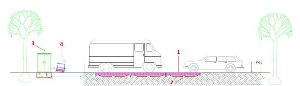
After identifying the traffic problem in Chapter 2, Paragraph 3, and selecting the suitable scenario to address it, the "DTGS" system is deployed in the problem area until the final configuration matches the depiction in Figure 2-10
Steps for correct installation are as follows:
Marking the areas where the system will be installed.
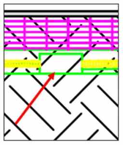
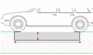
Excavating the marked areas with a width of 270 mm, a length of 1020 mm and a depth of 190 mm. Figure 2-11
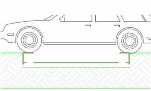
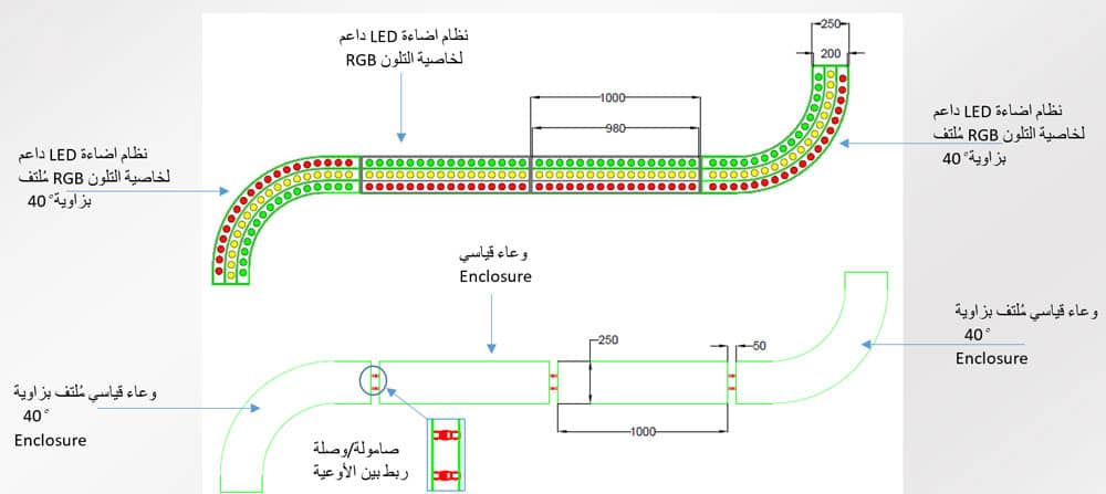
The enclosure of the system components is inserted inside the excavation site and is a specially designed to hold the system, its extensions and its various devices. Figure 2-12
The lighting system is inserted into the container, and electrical connections are made. Figure 2-13
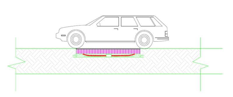
After the final step of installation, the shape of the system becomes identical to the cross view in Figure 2-10
The final figure is shown as a top view in Figure 2-14
As shown in Figure 2-15: An upper image of the “DTGS” with measurements where the path was planted by following the installation manual and connecting the standard pieces together as per the required design.
Features that increase the reliability of the Dynamic traffic guidance system "DTGS."
It is available with specific standard parts that can be customized and installed to solve the problem, regardless of the traffic scenario required.
The same recessed path, for example, can be used to serve multiple functions in conjunction with others.
Using the DMX protocol to facilitates the transfer of complex programming via a simple user interface is a smart choice.
Easy maintenance of the system is ensured as the internal extensions are designed for access without cracking or removing the road layers.


 February 18, 2025